


In a Guatemalan jungle, researchers using airborne laser scanning (LiDAR) have located more than 60,000 Mayan structures hidden by dense vegetation.
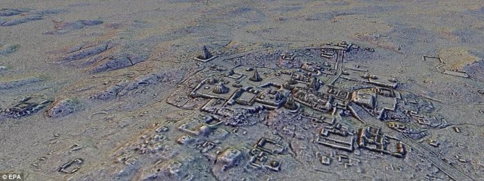
These structures include a pyramid complex and were surrounded by an extensive road network. Were they expecting us?
“Even though some previous studies had prepared us for this, just seeing the sheer number of ancient structures across the landscape was mind-boggling.”
In a study published in Science, Ithaca Institute archaeologist and co-author Thomas Garrison described Lidar scanning that began in July 2016 in northern Guatemala, near the Mexican border.
In a period of 6 years, they flew over 800 square miles of jungle, firing three laser beams at 300,000 pulses of light per second.
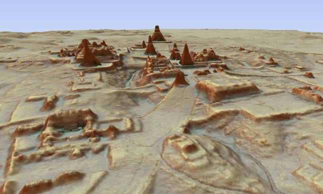
The lasers that managed to penetrate the canopy and then bounce back were picked up by a detector, which collected enough data to create a three-dimensional map of the topography with a resolution of one meter.
“Viewed as a whole, the terraces and irrigation canals, reservoirs, fortifications and causeways reveal an astonishing amount of land modification done by the Maya throughout their landscape on a previously unimaginable scale.”
Marcello A. Canuto, director of the Middle American Research Institute at Tulane and co-author of the study, described the incredible scenes archaeologists saw on the map.
It shows that the area was much more densely populated than previously thought, possibly between 7 million and 11 million people in this area of the Maya lowlands at its height during the Late Classic Period (650 to 800 AD).
Irrigation canals and farmland indicate how necessary and important agriculture was to this Mayan civilization, and how they changed the topology to accommodate it without the use of plows, techniques that could help farmers today.
The power of LiDAR was demonstrated in the discovery of the pyramid , a large structure that has somehow not been found in other previous searches in the area.
And the abundance of roads and fortifications indicates that the Maya were defensively militarized and fighting wars earlier than previously thought.
However, LiDAR mapping is limited in that it cannot identify what time period the various structures existed in, instead giving a picture that spans centuries of existence, as Garrison explains to Gizmodo.
“Not everything was occupied at the same time, and now it’s our job as archaeologists to figure all of this out. But we are happy to have these new problems!”